Who doesn’t like those animated charts?
Read here some tips to create this kind of visuals.

Management Consulting | Certified Qlik Data Architect and Business Analyst
Variables are really useful in Qlik. If you wish to create groups based in thresholds, this could be a good way to go. In the video below I show how to group Countries (for example) based on dynamic values, creating a new dimension that will be using variables to calculate which countries are in which […]
When you need to create separate files from the same table using a filter, this is a good way to go: Let’s consider that we have a table with many countries in the Country column and you need to split this table creating one csv file for each country. If you are new to Qlik […]
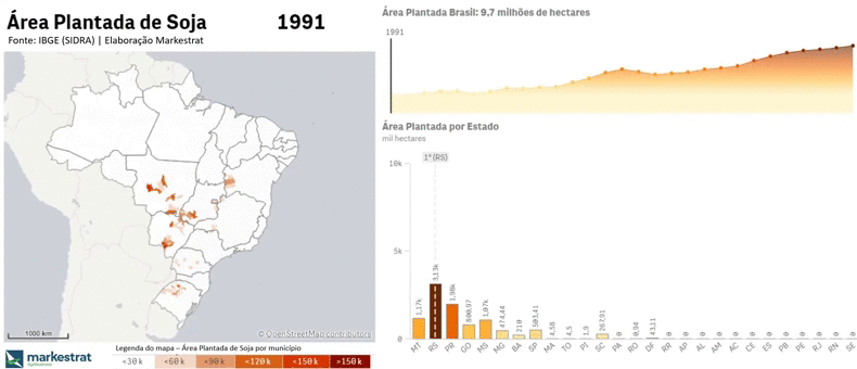
Nesse post a visualização foi criada usando Power BI. O portal SIDRA do IBGE é extremamente rico na diversidade de setores e no nível de detalhes em suas pesquisas. Considerando o nível de detalhe disponibilizado (município), é possível analisar área plantada, quantidade produzida e valor da produção de diversos cultivos. O dashboard abaixo foi criado […]
Existem algumas formas de automatizar a busca em páginas / web scraping, e eu sempre usei python para isso (módulos requests + pandas). Há um tempo, assistindo o canal BIdeAZ, vi que era possível fazer web scraping usando o próprio Qlik Sense. Usando FOR e variáveis podemos mudar a url de forma dinâmica e extrair […]
In this video/post I describe two ways to dynamically change the colors of your visuals in Qlik Sense. Click here to download the QVF created in the video. The first one is quite simple:Qlik uses the RGB color scheme, so we can color the visuals by expression using the RGB() function. Inside the function it […]
Did you know you can change the css class of your page without using themes? You just need a Multi KPI object (with a measure or dimension to “activate” it). In the Appearance section of this object you can change the css of the page elements. You can inspect the page elements to find the […]
Did you know we can import elements from any city using OpenStreetMaps and QGIS? And it is quite simple. OpenStreetMaps lets you export maps layers in a osm format, which can be read in GIS software like QGIS. It is quite simple to save the selected layer as kml. If you do so, you can […]
I used to scrape the web with Python (Beautiful soup), but it all changed when I found out how to do that with Qlik. In this video I demonstrate that by looping in a list of addresses and converting them in coordinates, finding in the html the latitude and longitude. There are lots of use […]
When exploring Kaggle, I came accross this Accidents dataset. I saw there were many interesting “Notebooks” and analysis about it, so I decided to create a simple dashboard to visualize accidents over time and on the map, also to explore the new “Animator” option in Qlik.